Pobeda: Elusive and Unrepentant, Part 2
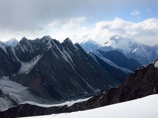
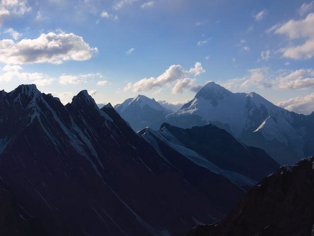
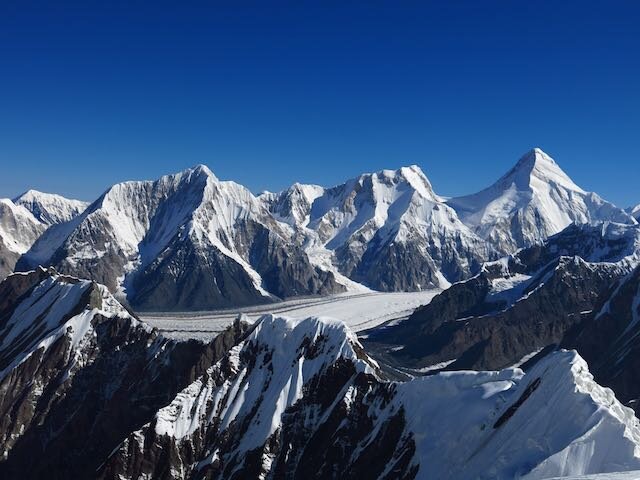
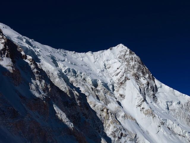
Day 1After breakfast, we took a slow and steady several hours to inspect each other’s gear, count GU packets, and weigh the pros and cons of couscous. After a few hours, in hot sunshine, we shouldered our monster packs and headed up the moraine. Soon, we traversed onto the ice of the Zvezdochka (Starry) Glacier. While beautiful, it was bright, hot, slushy and a maze of seracs and narrow river slots. Icy blue pools fed spectacular waterfalls. As we neared Camp 1, snow bridges became slushier and sketchier and we roped up. Just as we started to wonder where the Dutch tents would be, Bob led over a small rise and whooped out in joy…two beautiful tents were pitched in a broad, safe site just shy of camp one proper. We divvied up tasks and got to work re-anchoring tents and sorting gear. I fetched water from a nearby crevasse pond…we would use every trick in the book to save fuel.Day 2We wanted to get up through the serac band before sunrise, but when our alarm went of at 4 it was snowing and nasty out. We gladly took the extra hour or so of sleep before we brewed up, got dressed and marched up the glacier. Soon we could see an Iranian group working through the difficult sections above, and it was quite obvious why this portion of the route to Dikiy Pass was feared: a narrow and rotten gully was our only access to vertical/overhanging seracs fixed with lines. We romped up the gully as fast as we could, but the heat of the day was already softening things up and making the going tough. At the base of the seracs proper, Bob encountered a tricky overhang which took a few creative ideas and a ton of swearing to overcome. I ended up opting for my hands and knees on a dicey narrow ledge that we’d fixed with an additional ice screw. Just above, I popped through a snow bridge (protected by fixed line of course, but annoying nonetheless). The temperature was absurd. I’d say it felt like the upper 80s to 90s. All this with a monster pack and the inability to swap out 8000m boots for flip flops. After a mid day snack, I took the lead of the rope team as we entered the broad and gentle valley to Dikiy Pass. As we rounded a corner that gave our first views of camp 2 above, I saw a few climbers above moving slowly. Soon we reached two Iranians who were dealing with exhaustion. We didn’t feel much better and continued the last few meters to camp. A lone Russian wearing ski goggles and suffering from extraordinary sunburn plodded down at a snails pace. I stopped to say hi and learned that one climber had died on the summit ridge. No more details were exchanged as he continued to lumber down towards the glacier below. That evening, as we watched from our spectacular site we watched in awe as the entire Russian and Ukrainian contingents descended. They looked like hell. No fewer than twenty men, some collapsing every few meters slowly made their way down the ridge. It was an exodus. Soon, we were quite alone. The mountain felt different.Day 3We awoke to good conditions. The route to camp 3 looked beautiful and exciting, but once we wove out of camp 2 and got onto the lower buttress, things became challenging in hurry. The snow was deep and soft, and the hordes of climbers who had descended the previous day had turned the bootrack into sloppy ruts. The going got rougher when the wind and snow began to pick up. I donned my outerwear and our team regrouped to rope up at a small crevasse. Just a few meters later, things really deteriorated. In horizontal snow, we yelled over the wind for a bit before deciding to chop a platform and make camp. With the three of us working together, we stomped and shoveled a generous site, set up the tent and jumped in.___________________________________________________________________________I felt a punch to my chest and lurched upright in the darkness. Bob was trying to wake me but I was already beyond alert. The roar of the wind started so suddenly, Bob had thought an avalanche was barreling down on us and was bracing for impact. So much for the weather. We spent the next five or so hours til dawn getting hammered by wind and spindrift out of the west so violent that it filled our vestibule with snow and was starting to crush us. Periodically I sat up to punch the consolidating snow to clear some space for sleeping. By the time the morning came, we knew we were pinned down for the day. Bob, always a team player, got out and started shoveling first. Our tent had been buried to the brim on the uphill side and our guy lines were coated in rime ice. We learned that those above us at 6400m had an ordeal in the night but were okay.Day 4Later in the morning, things cleared in a most spectacular fashion. Below, a sea of snowcapped peaks stretched in all directions. The magic of the Central Tien Shan was alive. All of our stuff luckily got dry and we spent the day resting and discussing the weather. What would we do? Later in the afternoon the winds picked up. Soon, we heard shouting voices and exited to see two figures in the whiteout probing for crevasses below. We briefly chatted with the two Russians as they came by, asking about the whereabouts of camp 3 as they slowly postholed higher. Later that evening, we met Juho as he rapidly descended to camp 2, his summit bid over.Day 5After a string of increasingly alarming weather forecasts for the coming days, we decided to pack up and descend to camp 2. At least camp 2 was in a safe (we weren’t so convinced that our spot on the buttress was out of avalanche danger) and comfortable location. After a short descent to camp 2, we again were able to stretch out, dry our clothing and sleeping bags and enjoy the mountain a bit. But the forecast continued to deteriorate. Now, winds were expected to be 90 mph for a couple days, and the pattern after the major wind storm seemed unsettled, with a substantial snowfall forecasted afterwards. Did we have enough food to sit out the weather and still make a summit attempt? Even in the best of circumstances, we’d have no margin for extra days as our reserves of food and fuel would be depleted by a 4-5 day wait. After much deliberation, we settled on returning to base camp in the morning. And that’s when the fun began. I tore into scrambled eggs, sliced cheese, blueberry granola and pasta. No sense lugging extra weight back down the mountain. Plus, in the previous couple days we’d been purposefully starving ourselves to keep as much extra food as possible. In the evening, a huge serac ripped off the summit ridge and produced undoubtedly the largest avalanche I’ve witnessed. Though we were miles away and several thousand feet higher than where it landed, the powder blast steadily marched up valley and swept over us and into the Dikiy Glacier valley. We were now quite alone on the mountain, as only the Russian pair were above us. I rested well knowing our mission was clearer though we still needed to return through some tricky terrain to base camp.Day 6We woke up to another spectacular day. With our systems and teamwork now dialed, we packed up and roped up for the glacier below. The route was spectacular in early morning light and the firm snow made for enjoyable cramponing. Soon we reached the top of the fixed lines as a few climbers ascended on their own summit bids. The glorious weather and the presence of others pushing higher made us openly question our decision. We remarked that while we certainly didn’t want anyone to get into trouble, we almost wanted the weather to get nasty to justify our bailing in such perfect conditions. By noon I reached the comfort of base camp, now more of a deserted tent city. Relaxed and happy, my journey into the unknown was over.AftermathAs predicted, the storm rolled through. Winds first started to roll over the ridge, then things got nasty in base camp. People were holding the dining tent down for dear life. Some tents were blown away in base camp. Reports from the Russian duo, now in a snow hole at 6900 were of 135 kph winds and being pinned down.Pobeda: Route overview and considerations above our high point Camp 3 (5800m)Simple, but somewhat avalanche-prone slopes from Dikiy Pass. There was a huge snow cave there, which could be used to escape extreme weather. But in the Russian/Ukrainian exodus following their assault, this had essentially been turned into a field hospital. We let our minds run wild as there were reports of trash, blood, vomit and discarded dexamethasone needles.Camp 4 (6400m) Looked like fun and moderate climbing up the first rock band and in and out of couloirs to this airy perch. You know you’re getting close when you see the dead guy from last year. While somewhat sheltered, there’s space for just three tents. No snow cave option. Iranians were stuck here for six days. A tent collapsed here during our eventful night at 5600m.Camp 5 (6700 or 6900m)Sounded like there were snow cave options in either of these locations. West Pobeda (6900m) would be the only option for a one-day summit push that skipped the 7100m obelisk camp. Despite the simple climbing above 6400m, they both sounded like death traps. Go up there, get in a snow hole, and pray that the weather lets you get down.Summit Ridge This thing simply gets hammered with insane winds, usually out of the west. Every. Day. During my several week stay here, I observed just two days that would have been good to be up there. Let’s say an average day is 40-50 mile per hour winds (gusts can knock you over!). At 23,000 ft, air temperature in the vicinity of 0 °F. During the bad times the ridge is obscured by a giant cloud and snow plume. Winds were as high as 90 miles per hour (72 is a hurricane). On several occasions, we observed wind driven over a kilometer off the summit into western China.
Return of the Snow Leopard: The Film
Here's the short movie I filmed and edited as it happened. Enjoy!HariReturn of the Snow Leopard from Hari Mix on Vimeo.
Pobeda: Elusive and Unrepentant, Part 1
“It is better to return to Pobeda ten times than to not return once” –Gleb Sokolov
Fifty-nine mountains are higher. Plenty are steeper. But few are harder. Despite it’s relatively moderate climbing, Peak Pobeda routinely turns back—and kills—those who don’t take it seriously.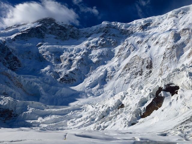 Following several weeks of acclimatizing and strategizing, Pobeda casually thwarted our strong and competent team over a vertical mile below its summit. Here is the story:Day 0For days, base camp had been abuzz. Prior to potential summit windows, these places become infested with gossip, anxieties, impressive gear spreading, and endless conversations about the weather.Thirty or so Russians and Ukrainians, ascending in what can only be described as a military siege, were nearing the summit. Excitement was in the air, but with the short climbing season nearing its close, the rest of us sized up the others and scrambled to make arrangements. It was a veritable hodge-podge of mostly small teams.My own thinking and organization began to crystalize around a few core concepts: 1) Don’t do anything stupid, 2) I knew that despite my perfect health and strong climbing below 6000m, I had limited acclimatization. I was able to climb from base camp to Khan Tengri’s Camp 3 (5900m) in seven comfortable hours, but I only had one night there and two at 5600m. I needed a slower, more conventional ascent on Pobeda in order to acclimatize on the mountain. No sprinting to a snow cave at 6900m in just a couple days, 3) I needed the security of extra food, fuel, and strong shelter. This was shaping up to be the biggest pack I’d ever lugged…about two weeks of food and fuel. And my clothing system was outrageous—as warm as gear is made.All three factors drew me to joining an American couple living in Canada. Bob, a contractor and former Alaska Range guide, and Katherine, a philosophy professor with a calm, determined mind, had tons of big mountain experience, and I could tell that by partnering with experienced Americans, we had similar philosophies, risk tolerances (hell yes we were roping up on the lower glacier) and strategies for the summit. We got along well personally, which we knew would be vital for the inevitable tentbound storm days. We would try as hard as we could within our safety bounds. Team America was born.
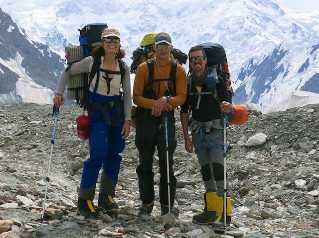 One hitch…we didn’t have the ideal shelter solution. I had a two man single-wall tent and they had a double wall, but essentially a one-man tent. We needed to distribute weight better: one tent, one stove. I set off on a multi-day and impressive, if I dare say so myself, diplomatic mission. Within a day, I brokered a straight up trade with a Dutch trio for our pie in the sky dream tent: a Mountain Hardwear Trango 3.1. Double wall. Strong as hell. And downright palatial. My single wall was perfect for their objective.____________________________________________________________________More writing coming as I get more juice. I am in base camp waiting out the storm. It is bad, even down here. Hopefully heli to Bishkek tomorrow!Hari
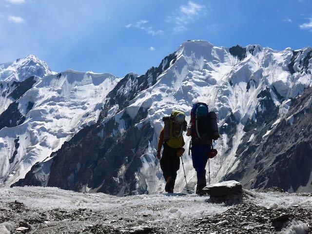


Return of the Snow Leopard
 Greetings from Bishkek, Kyrgyzstan! My five year love affair with the high mountains of Central Asia continues. This time, I return to the Tian Shan, the Celestial Mountains, to attempt Peak Pobeda. Known for some of the world's worst weather, Pobeda is certainly the crown jewel of the former USSR's five 7000m "Snow Leopard" peaks. I was hoping to write a more thought out piece but I have had too much to do in the mere 24 hours since my arrival. But I am in excellent physical, mental and emotional health, and I look forward to the journey ahead. I will have plenty of time ahead for reflection, writing, relaxation, and of course, good old fashioned suffering. It will be an adventure.Nuts and bolts: The Journey from HereIn two hours I depart for Karakol, near the banks of the great Issyk Kul. The next day we'll drive to At-Jailoo (jailoos are summer pastures) in the extreme northeast of Kyrgyzstan. The next day, early in the morning before the braided rivers swell with glacier runoff, I'll begin a six day trek up the Inylchek River and South Inylchek Glacier. Once there, I'll spend a few weeks climbing and acclimatizing on a few peaks including Khan Tengri (7010m) before attempting Peak Pobeda (7439m). More to come...I'm off to catch this jeep!How to (and how not to) follow alongI'll be out of good contact starting now. I will carry a SPOT messenger with me to post OK messages periodically, but I can't make guarantees about the frequency or quality of my communication until August 16 or so. I expect to check in within at least 8 days (my arrival at base camp) and weekly-ish after that. To track my progress, click the "Where's Hari??" link at the right of the header.Thank you to the American Alpine Club's Live Your Dream Grant and Osprey Packs for supporting this expedition!!!Take care,Hari
A mini piggyback
 I'm back to my usual summer pattern of getting into my research while simultaneously disappearing into the mountains for a while. This summer's travels started with a mini "piggyback" - a combo research and field adventure. This time, Sean and I headed to San Diego to give a talk and have some meetings at Scripps Institution of Oceanography. Scripps is filled with bright and energetic people who somehow manage to get work done despite their idyllic setting.
 After a few days of productive discussion, we headed north to the Eastern Sierra. Aiming for some alpine rock routes in the Whitney region, we shouldered packs with a few days of supplies and headed up the North Fork of Lone Pine Creek.


 Unfortunately, morning showers and even stronger afternoon thunderstorms prevented us from getting on any of the technical routes, but it was a great trip nonetheless.
Big Will and the California Fourteeners

"Going to the mountains is going home" -John Muir
It's been too long. I joined the machine and got a "Real Job." I built my own lab this past fall (more on that later!). But the High Sierra are my home away from home. Last weekend I completed a seven year journey to climb each California's fifteen peaks over 14,000 ft...and each with a twist, be it a linkup, speed ascent, winter ascent or a non-standard route.
 No peak was more challenging nor turned me back more than bulky Mount Williamson. It's not that Williamson is the most technical, nor the most mileage. It's just one of the bigger, more inaccessible piles of rubble you'll encounter. Williamson's routes are nearly Alaskan or Himalayan in proportion as they start from the Owens Valley floor, over 8,000 ft below the summit. They involve miles of up and down trail, thousands of feet of bushwhacking, scree, scrambling or rock climbing. For my fifth (or thereabouts) attempt on Williamson, I opted for the loose, brush-filled, icy boulder-hopping, snow climbing and scrambling sufferfest that is the North Fork of Bairs Creek. I don't know what's wrong with me but I eat this stuff up!
 I got a super late start on Saturday because I-5 had been closed the day before due to an accident. I climbed the 1,500 or so feet to the "hard to find" notch, dropped down into the icy creek bed, and ascended thousands of feet of loose rock, willows and thorns to a decent bivy spot at ~9,600 ft. I felt quite good, hydrated well and had a nice dinner of noodle soup before turning in for the night. In the morning, I brewed up, hydrated and boulder hopped thousands of feet up to the crux of the route, a snowy couloir that provided excellent cramponing up to the 13,000 ft plateau beneath the summit slopes. A while later, I was on top, making the first winter ascent of the season and with the high sierra to myself. A fast and relatively uneventful descent (minus some inevitable thrashing) had me eating a nice dinner in town.


 The Fourtneeners, a retrospectiveThanks to all with whom I shared these magnificent adventures...they wouldn't have been the same without you!! Here are some highlights from fourteener trips...Langley (with Mike) We went up this one dry Thanksgiving via a variation of Old Army Pass. The climbing wasn't the most memorable, but Mike ate a heroic amount of french fries in Lone Pine!
 Russell, Whitney, Muir (and Keeler Needle) (with John and Dave) What a blast. We went up the East Ridge of Russell...perhaps the finest 3rd class route I've ever been on (sorry Keyhole Route on Long's Peak). I threw in Keeler and Muir for good measure and then had a death march back to the Portal.
 Williamson Can't count the times I've said I was going to do this, but I made it up Shepherd's pass a couple times alone and with Warren, not to mention the honest effort on the Northeast Ridge with Brad
 Tyndall One day winter ascent with Warren who also liked big days in winter.
 Split Mountain Tried once before I soloed the St. Jean Couloir in winter. Wish I hadn't lost my camera after the ascent!
 Middle Palisade I ran the stellar East Face route in 7:28 round trip, which I think due to some strange technicality may be the fastest known time. It's hard to imagine given how fast the 14er records are these days that this wouldn't be hours faster. Nonetheless, a fine day in the mountains on one of the nicest peaks in the high country. Brainerd and Finger Lakes are the gems they're talked up to be.
 Thunderbolt, Starlight, North Palisade, Polemonium Peak, Mount Sill (with Warren) The Palisades Traverse is still the longest day I've ever had in the mountains, a full 26 hours (2 sunrises in one day!!!). What a spectacular adventure. We didn't summit Sill, but I climbed the North Couloir after graduating undergrad only to break my arm tripping on the trail at First Lake (sorry Dad and Sue!)

 White Mountain Peak Casually ran this in 2:58 car to car, also a fastest known time. Same as Middle Pal, I'd be shocked if some Yosemite hard man hasn't run this faster.Shasta (Tried a couple times, first with Leor, turned back due to insane winds) Finally got the weather right after my first expedition to Nepal in 2010. I soloed the Casaval Ridge in 27 hours...Stanford to Stanford. Just 11 hours on the route proper. One of my finest days ever in the mountains. Sunrise from the Catwalk was among the best I've ever seen.
Winter traverse of the High Sierra
 With all of the recent polar vortex talk, it could be easy to conclude that winter, glaciers and climate as we know it are here to stay. Well, out here in California, my good friend Zach and I just crossed the Sierra Nevada. In sneakers. In two and a half days in the heart of "winter." California, if you haven't heard, is in a ridiculous drought right now.Zach and I were excited at the prospect of this unique trip and a chance to visit some of California's threatened glaciers in winter. Borrowing from the light is right, alpine-style ethic, we stripped down to the bare essentials and rock hopped, plunge-stepped, and slipped along icy trail from the Eastern Sierra to Yosemite Valley.


 Thanks to Brad and Matt for dropping us off in style, and Seanan for the unlikely encounter in Yosemite and company on the way home!
Rising mountains dried out Central Asia
 Something has come of those two summers spent bouncing around Mongolia in Russian vans! Work led by my fellow grad student and travel companion Jeremy Caves has been presented, submitted for publication, and picked up by a few science news aggregators. This piece, written by Stanford's earth science writer Ker Than, puts some of our findings into English...-----------------------------------------------------------------------------------------------------------------------------Rising mountains dried out Central AsiaA record of ancient rainfall teased from long-buried sediments in Mongolia is challenging the popular idea that the arid conditions prevalent in Central Asia today were caused by the ancient uplift of the Himalayas and the Tibetan Plateau.Instead, Stanford scientists say the formation of two lesser mountain ranges, the Hangay and the Altai, may have been the dominant drivers of climate in the region, leading to the expansion of Asia's largest desert, the Gobi. The findings will be presented on Thursday, Dec. 12, at the annual meeting of the American Geophysical Union (AGU) in San Francisco."These results have major implications for understanding the dominant factors behind modern-day Central Asia's extremely arid climate and the role of mountain ranges in altering regional climate," said Page Chamberlain, a professor of environmental Earth system science at Stanford.
 Scientists previously thought that the formation of the Himalayan mountain range and the Tibetan plateau around 45 million years ago shaped Asia's driest environments."The traditional explanation has been that the uplift of the Himalayas blocked air from the Indian Ocean from reaching central Asia," said Jeremy Caves, a doctoral student in Chamberlain's terrestrial paleoclimate research group who was involved in the study.
 This process was thought to have created a distinct rain shadow that led to wetter climates in India and Nepal and drier climates in Central Asia. Similarly, the elevation of the Tibetan Plateau was thought to have triggered an atmospheric process called subsidence, in which a mass of air heated by a high elevation slowly sinks into Central Asia."The falling air suppresses convective systems such as thunderstorms, and the result is you get really dry environments," Caves said.This long-accepted model of how Central Asia's arid environments were created mostly ignores, however, the existence of the Altai and Hangay, two northern mountain ranges.Searching for answersTo investigate the effects of the smaller ranges on the regional climate, Caves and his colleagues from Stanford and Rocky Mountain College in Montana traveled to Mongolia in 2011 and 2012 and collected samples of ancient soil, as well as stream and lake sediments from remote sites in the central, southwestern and western parts of the country.The team carefully chose its sites by scouring the scientific literature for studies of the region conducted by pioneering researchers in past decades."A lot of the papers were by Polish and Russian scientists who went there to look for dinosaur fossils," said Hari Mix, a doctoral student at Stanford who also participated in the research. "Indeed, at many of the sites we visited, there were dinosaur fossils just lying around."The earlier researchers recorded the ages and locations of the rocks they excavated as part of their own investigations; Caves and his team used those age estimates to select the most promising sites for their own study.At each site, the team bagged sediment samples that were later analyzed to determine their carbon isotope content. The relative level of carbon isotopes present in a soil sample is related to the productivity of plants growing in the soil, which is itself dependent on the annual rainfall. Thus, by measuring carbon isotope amounts from different sediment samples of different ages, the team was able to reconstruct past precipitation levels.An ancient wet periodThe new data suggest that rainfall in central and southwestern Mongolia had decreased by 50 to 90 percent in the last several tens of million of years."Right now, precipitation in Mongolia is about 5 inches annually," Caves said. "To explain our data, rainfall had to decrease from 10 inches a year or more to its current value over the last 10 to 30 million years."That means that much of Mongolia and Central Asia were still relatively wet even after the formation of the Himalayas and the Tibetan Plateau 45 million years ago. The data show that it wasn't until about 30 million years ago, when the Hangay Mountains first formed, that rainfall started to decrease. The region began drying out even faster about 5 million to 10 million years ago, when the Altai Mountains began to rise.The scientists hypothesize that once they formed, the Hangay and Altai ranges created rain shadows of their own that blocked moisture from entering Central Asia."As a result, the northern and western sides of these ranges are wet, while the southern and eastern sides are dry," Caves said.The team is not discounting the effect of the Himalayas and the Tibetan Plateau entirely, because portions of the Gobi Desert likely already existed before the Hangay or Altai began forming."What these smaller mountains did was expand the Gobi north and west into Mongolia," Caves said.The uplift of the Hangay and Altai may have had other, more far-reaching implications as well, Caves said. For example, westerly winds in Asia slam up against the Altai today, creating strong cyclonic winds in the process. Under the right conditions, the cyclones pick up large amounts of dust as they snake across the Gobi Desert. That dust can be lofted across the Pacific Ocean and even reach California, where it serves as microscopic seeds for developing raindrops.The origins of these cyclonic winds, as well as substantial dust storms in China today, may correlate with uplift of the Altai, Caves said. His team plans to return to Mongolia and Kazakhstan next summer to collect more samples and to use climate models to test whether the Altai are responsible for the start of the large dust storms."If the Altai are a key part of regulating Central Asia's climate, we can go and look for evidence of it in the past," Caves said.
More thankful than ever
 I live a charmed life. Occasionally I’ll be stopped in my tracks when I stumble upon an old photo…was I really there? Did I actually drink fermented camel’s milk in Mongolia?!?This year, I have even more reason to be thankful. It’s also the main reason I haven’t posted in a while. Next year, I'll be an assistant professor in the Department of Environmental Studies and Sciences at Santa Clara University. It’s an absolute dream for me to make this next step, and I couldn’t be happier at the prospect of joining such a wonderful group of people.
 I wasn’t able to get out much this fall as I was super busy with the job search and PhD work. I also messed my ankle up really badly in late September. I’d never rolled my left ankle before but I tore pretty much everything. I’m in really good running shape now and lifting as well, but mountain trips were off limits this fall. I did sneak off to Yosemite Valley for a quick weekend with my good buddy Mike. He led all the hard pitches and I climbed pretty poorly but loved every minute. Found a great veggie burger and milkshake on the way home too…Hula’s in Escalon is tasty!
Lhotse: Full photos and video
Hey everyone,Thanks for following along this spring! I've finally had a chance to get through all of my images. Here's a look back at the best of Nepal:Best of Lhotse [embed width="420" height="315"]http://www.youtube.com/watch?v=K3sFlAaw5EA[/embed]
Everest’s neighbor: A case for Lhotse
Choosing the right objective is always a huge part of climbing. The bigger the peak, the bigger those considerations. Just on a practical level, if you’re going to commit a lot of effort and a couple months towards something, you should be happy about the idea. I’m climbing what many people would call an unusual mountain this spring—there’s not a lot of attention for Everest’s slightly shorter neighbor, so I’d like to let you in on what gets me excited about Lhotse.A crash course on the world’s highest mountainsThere are fourteen 8000m (26,200ish ft) peaks in the world. Obviously, just as with Colorado’s 14ers, it’s an arbitrary cutoff. Here’s the way the elevation and difficulty breakdown of the normal (commercialized in some cases) 8000er routes looks to me: …..big gap of nearly 1000 ft from Everest to K2…..

 …..big gap of nearly 1000 ft…..Cho Oyu through Shishapangma 8000ers #6-14 are between 8200m and 8000m and vary greatly in their difficulty, remoteness, and danger.I’m pointing this out because these really is an enormous physiological difference between 8000 and 8500m. When you add in the architectural differences of these peaks, this becomes even more obvious. For example, on Everest, you need to camp at nearly 8000m on the south side and most people “camp” at 8300m, higher than the world’s 6th highest mountain, on the north side.I’m interested in exploring a type of direct interaction with the mountains. Extremely high altitude certainly isn’t my only focus, far from it, but it is pretty wild up there. Just overcoming the apathy, staying calm, plugging away and just taking care of yourself (for potentially 7-8 weeks!) sounds like it could be up my alley. So this will be my first try.Why Lhotse? Well, first off, I wouldn’t be on this trip without the Extreme Environments - Everyday Decisions research project and some huge supporters, so thanks! I’m still just a grad student, and this is the first time I’ve taken a couple months of unpaid leave to make something happen. I definitely wouldn’t be on a peak this expensive with such a quality operation without a tremendous amount of help. If you want to see some of the organizations that have helped made this possible, check out the Partners page.So, in choosing a first 8000m peak, there are some patterns that you can see. A few 8000ers have been somewhat designated as good choices…Cho Oyu, the world’s 6th highest peak being a great example. Cho Oyu has become somewhat of a primer for Everest, and a lot of commercial clients are now getting guided up Cho in the fall before an Everest summit bid the next spring. Manaslu and Shishapangma have also seen a lot of commercial attention. All of these peaks are in that 8000-8200m bracket of elevation, and something like Cho Oyu is a very straightforward technical climb. As I’ve had a “good” time on some of my previous 7000m peaks and I’m going with a great deal of commercial support, I’m feeling confident enough to try a peak that’s a bit higher. This wouldn’t matter if I were using oxygen, but we’ll get to that. I also am really drawn to slightly steeper peaks for aesthetics and enjoyment of the movement. Even though I have fairly limited technical ability, I still want this to be more than a pure snow slog.Ok, the world’s five highest peaks:Everest…In a category of its own in a lot of ways. Without oxygen though, it’s a completely different beast, even compared to Lhotse. Honestly, climbing both Lhotse and Everest was on the table (at least in my head), but after talking with my expedition leader, Lhotse became the clear choice.K2 and Kangchenjunga…Not in play for first 8000m peaks for me. We all make our own rules in climbing, but those weren’t even a consideration. This was just an honest personal assessment about my experience and willingness to take risk. I realized that I don’t even know enough to break down how I would climb those two, even though its probably possible. The more important question is if it’s right, and I know it’s not. Both are too big, too hard, too remote and have a bunch of objective dangers that I don’t know enough about at this point.Lhotse…This was the obvious decision given that our project is to study commercial operations on Everest. This allows me to be in the same base camp, climb almost the entire normal route on Everest before deviating off to Lhotse on summit day. Also, given my limited resources, Everest would have been a huge financial commitment, and I just want to go climbing for two months.Makalu…Ok, I really really would have liked to try Makalu. If I enjoy myself this spring and have a good team I’d stay open the idea. Compared with Lhotse though, it would definitely be more remote and more difficult, so I’m probably doing this in a more controlled way as it is.Commercial MountaineeringI’m probably not going to do a bunch more commercial trips…certainly not big, pricey, full-service guided trips. If I do, I’ll probably take some degree of commercial logistical and base camp support like I did last summer in the Pamir, but choose to climb with peers. I think commercial mountaineering serves some great purposes for me though. I was told by a friend not to increase more than one variable at a time in climbing. I’m trying my best to stick to that, and the bottom line is that doing Lhotse with this degree of support in place makes it a much safer and more controlled experiment. I have a lot to learn, and it'll be great to be mentored for a while.Usually, I find that the more that my partners and I handle as teammates and peers, the more rewarding the experience. In this case, I guess I have enough respect for true modern alpinism that I’m dipping my toe in the waters before jumping in. When I do what I consider real alpinism, it’s usually on peaks that are much more firmly within what I see as my capabilities. I’ve only teased it in the big mountains. If it turns out I like it, hey, I’m young and the mountains will still be there.OxygenSo, I’m adding just one variable back in. Look, it’s 2013…there’s 3G cell service up there! I’m not forgoing amazing boots, refusing to get any route information, or plugging my ears when someone is reading off the latest custom weather forecast off the internet. And we will have oxygen available…I’ll be climbing with a sherpa on oxygen, who will have an extra for me in the event that I need it. I’m not saying going without, umm, air is a good idea, but we're definitely making compromises.
 Not using oxygen is an enormous difference though. Check out the graph above from Tom Hornbein, an American Everest legend. Even if these numbers aren’t exactly right, it should give us some idea. These days, it’s pretty common for people to sleep on 0.5L/min starting over 7000m and on summit day, 2L/min is a common flow rate. Some climbers will even pay for extra bottles and use 4L/min. If these curves are in the ballpark, it basically could turn the summit of Everest into a 7000m peak, perhaps lower. So for me, even though using oxygen certainly would not be easy or a guaranteed summit, I'd like the opportunity to try something I genuinely don’t know if I can do.I’m not sure I have a very crystallized opinion of oxygen use in general, and it’d be pretty pointless for me to mouth off about it since I haven’t yet been on a peak high enough to warrant its use. With regards to my own personal use of supplementary oxygen, I feel that as long as the defining attribute of the route on Lhotse is that it’s very high, I should experience the mountain for what it is. That’s my feeling with all of my other climbs, from gazing up at Longs Peak as a child and wondering just how high it was and what it was like up there to now. I don’t want to sanitize the experience. I want direct interaction with the mountains, the naked vulnerable feeling of being out there more than I want to summit.A devil’s advocate argument typically follows. Something along the lines of, “Well, you’re wearing down, isn’t that an artificial advantage? Why not go with the clothes Mallory wore? Why not climb the Kangshung Face of Everest naked?” Well, I guess because I’m not arguing anything. One of the things I like most about the mountains is the sense of true freedom, and that all possibilities are open. There are of course, certain limitations. We must not harm the environment and our wild places. We must be fair to local peoples. But those answers are beyond the scope of this discussion. Be a good person. Do what you want to do. This is me.
Getting dressed for an 8000er
[embed width="420" height="315"]http://www.youtube.com/watch?v=2F2WeQZ1Nng[/embed]
Assembling the Pieces
I haven't written anything in a while and it's hard to say quite why. The simple answer is that I've been busy. This quarter was spent working on a chapter of my dissertation and teaching a sophomore seminar on climate change. While writing and revising a discussion section on stable isotope records of Neogene climate and temperature change in western North America from the clay mineral smectite was as tedious as writing this sentence, the payoff for the upfront struggle was huge. I'm finishing revisions on the final required chapter of my thesis and looking forward to maintaining the momentum I have with my PhD even during the expedition. In addition to work, I moved out of my apartment before I ship off to Kathmandu (tomorrow!!), to mention nothing of expedition prep...countless meetings to coordinate with our research team on data collection protocols; a constant barrage of phone, email, and skype conversations sourcing equipment, working out expedition logistics and finances...even a five-day trip to Salt Lake City for the Outdoor Retailer show, the catch-all meeting of the outdoor industry. In short, it's been hard to even conceive of writing about mountains because I've been working so hard to pull this off, the last thing I want to do when I come home is write about climbing. Yes, just as with high altitude climbing itself, there's a lot of effort for that distant glimpse of the great unknown: Maybe, just maybe, it'll all work out and I'll briefly visit the summit of Lhotse. Regardless, I'm in for a quality adventure, an amazing cultural experience and an unforgettable season.OK, enough with the editorial...the past few months have filled me enthusiasm and strength for what's to come this spring, and it's time to fill you in on what I've been up to with this little side project. Winter rock and alpine explorationIt hasn't all been office work, schmoozing and dreaming...I've been out to climb a fair amount. Mostly small trips out rock climbing in the area, but I've made a few forays into the alpine as well. Hmm, let's see...Just after the New Year, I spent a few days up in the eastern Sierra climbing with my good friend Brad. In a little under a year, Brad has become a wonderful friend and trusted partner. Just as with a romantic relationship, it's really hard to find the right fit, and things just clicked between us. We have similar style, objectives, and get along well together, not to mention that Brad has a bit more skill and experience than I do on technical rock and ice. On our first day, we went ice climbing up in Lee Vining Canyon, home of California's best ice. Shortly after leaving home, I realized I'd forgotten the camera (sorry!). I tried leading the first pitch of the day, which ended up being pretty hard with brittle vertical ice "dinner-plating" pretty badly. Later, we moved to an easier wall which Brad led beautifully and I had a fun time following. We then headed up on a challenging but spectacular approach into the high alpine above Bishop. We tracked up gorgeous drainages above Lake Sabrina hoping to attempt the North Face of Mount Darwin the next day. That night, my sleeping pad had developed a nuisance of a leak the night before which required me to reinflate the pad hourly to keep me insulated from the snow. After ascending a beautiful snow couloir the next morning, we soon realized that we were one drainage north of our intended summit and opted to take in the views on the Sierra crest just south of Lamarck Col and hike out. We had a hell of a bushwhack on the way out, that's all I'll say. Climbers define this as "Type II fun," a euphemism for "pleasant only in retrospect." And really, that's all I was after in preparation for this expedition..some character-building willows buried under a few feet of powder just waiting to rip a snowshoe off.
 I also got out to Pinnacles National Monument with my good friend Mike to try a cool adventurous traverse of the largest feature in the park, Machete Ridge. This wild traverse on so-so rock was a great way to spend a beautiful day. I think it also has the distinction of being the only route that I've done that's a net drop in elevation--the route traverses the skyline from right to left. And certainly the crux was the mungy, poison-oak-covered descent. Good times!
 Big Will
 The biggest climbing project of the winter was a route Brad and I had been eyeing for a while...the Northeast Ridge of Mount Williamson, California's 2nd highest peak. I've managed to climb 14 of California's 15 14,000 ft peaks, all either in winter, solo, quickly, or via a challenging route. Williamson, however, has thwarted my advances a grand total of five times, mostly due to lack of motivation. It's just a beast. Brad and I planned on 3 days to climb out of Owens Valley and up the several miles of technical, serrated ridge to the summit. Our first day was an absolute monster. Even after stripping down the weight to what we thought were the bare essentials (Brad brought only a 32 degree bag and slept on the rope for extra insulation, I jettisoned the extra fuel and only took thin jackets), our packs were still unbearably heavy. Our ascent began by meandering through sage brush in the Owens Valley, then ascended several thousand feet of loose sand, decomposing granite and soft snow (more type II fun).
 We ended up having a somewhat difficult night, as we were unable to find much of a ledge, I was feeling the altitude, and Brad was cold in his thin summer sleeping bag. The next morning, we brewed up and immediately started up the knife edge ridgeline above. This portion of the ridge was made of excellent granite and was a joy to climb. After a few technical sections, the route gave way to an easy portion of talus, then required us to climb up and over or around several prominent towers.

 After nearly completing the middle portion of the ridge, we were finally staring at the huge talus slope leading to Williamson's East Horn, a 14,000ft subpeak. Beyond that, we knew we'd reach a point of no return. Feeling a bit committed as we were running low on fuel and motivation, we sat in the sun and deliberated. Both of us have "gone big" before, and both of us have bailed. As we were sitting around in the sun just feeling it out, it was clear that neither of us was going to make an impassioned plea to continue. Soon thereafter, Brad scouted and rigged a rappel to get us off the snowy ridge into a snow couloir which we glissaded and downclimbed to Bair's Creek.
 Trial RunLastly, I'd been planning a run up Green Butte Ridge on Mount Shasta as the perfect trial run for myself physically and mentally. I also needed to test my updated layering system and footwear system in an alpine environment to see how things worked together. With an excellent weather and avalanche forecast this past weekend, I drove up to Bunny Flat, shocked by the lack of snow for this time of year. I settled into my sleeping bag for the evening with winds gusting to the extent that they rocked the car. By the time my 3AM alarm went off, I knew there was no point in attempting the summit--winds this high at the trailhead would mean that conditions would be unreal on the ridges. In the morning, as I was suiting up, a ranger came by and told me the winds registered 92mph at a nearby station, so I'm sure they'd be well over 100 on the ridges. I opted for a nice snowshoe up to treeline, and had a nice time testing out my footwear system and some of the other new clothing and tech items I'll use up on Lhotse.
Big Up: Announcing the Everest-Lhotse Research Expedition
"I am nothing more than a single narrow gasping lung, floating over the mists and summits" -Reinhold Messner on the first ascent of Everest without supplemental oxygen
 When did it all start? Thinking back, it's hard to pinpoint a specific moment. I've definitely had defining moments hiking in the Canadian Rockies and certainly on Colorado's Longs Peak, but I sense the idea had a more subtle beginning. As early as age five, the cover of our family's copy of the world almanac started to develop a visible crease. I would repeatedly flip to the same page and scan the list of the world's highest mountains, memorizing and typing spreadsheets of the 14 peaks that reach over 8000m. I drew maps of Asia, annotated with locations of great peaks in Nepal, Pakistan and Sichuan.So when I sat down with a group of researchers with a group of researchers interested in conducting a study on decision making on 8000m peaks this spring, I didn't exactly need to do any background research. When the conversation turned to the subject of me getting support to climb and collect vital data, I had to ask repeatedly ask the obvious, "You want me to go climbing?!?"I always told myself that if I was offered the chance to climb a really big peak, I'd take it. Well, it wasn't so simple. First, I had to clear some initial hurdles: "You need to think about your priorities." My advisor wasn't trying to limit me, but rather to make sure I'd considered that there's an opportunity cost in every decision we make. Then came the talk with my parents, who have had to bear the unfair emotional burden of my climbing. I get to experience all the adventure, challenge, and connection with the natural world, all while leaving cryptic messages about stomach illness and whiteouts in my wake. After my accident last summer, I considered dropping big expeditions altogether for my family's sake.Then things turned to the reality of the trip and the complicated set of office tasks it takes to pull off a major expedition. This fall, I've taken on this side project...a part time job of sorts. I've been working tirelessly writing grants, discussing details with expedition organizers, equipment manufacturers and the like, all for a shot at a big peak. I ended up convincing the research team that climbing the West Face of Lhotse, the world's 4th highest mountain, without supplemental oxygen was the objective that spoke to me most while meeting team needs. The style and objectives of this expedition align with my interests in a way that I can put my full effort into making sure that we succeed on a number of levels. Lots more on that later. So...what are we actually doing?Extreme Environments, Everyday DecisionsThis expedition will produce the most comprehensive study of what it takes to climb the world’s highest peaks and the organizational framework necessary to return from them safely. Our research is led by Associate Professor Markus Hällgren, whose Extreme Environments – Everyday Decisions (www.tripleED.com) group examines how organizations operate in settings where the wrong decision endangers lives (he's also working on emergency rooms). The increasingly commercialized nature of high altitude mountaineering provides an excellent laboratory to examine the challenges of upholding safety in the face of changing conditions. Previous studies of decision-making at high altitudes have focused almost exclusively on disasters, while everyday organizational behavior has been largely ignored. We feel that this research will be of great value, not only to the mountaineering community but to the greater pubic, as many parallels exist between expeditions and team projects of all kinds.So I'll be part of a team of researchers documenting the entire course of an Everest expedition, starting with the preparation we've begun months ago until well after we head home in June. Several researchers will trek to base camp and conduct ethnographic interviews of climbers, expedition leaders, Sherpas and doctors. In addition, we will collect other qualitative data such as photos, video of team meetings, recording radio communications, etc. I'll be in charge of data collection on the upper mountain. While I'll be personally attempting Lhotse, I will be interviewing Everest climbers on the upper mountain, recording climbing and impromptu decisions with a helmet camera, taking field notes and research photos from some of the highest altitudes on the planet. I will also continue my work with Adventurers and Scientists for Conservation, and I'll include several climate change research projects to the expedition as well. If you want to see more about this, my work with ASC last summer was recently profiled by Outside.Stay tuned for lots more on this spring!Hari
Go Big and Go Home
 Brad and I got an early start out of Jasper and headed back up towards the Columbia Icefields to try some classic multipitch ice routes. With stormy conditions and high avalanche danger, we decided to back off our big objectives, and opted to climb Louise Falls in the afternoon.
 I led my hardest pitch yet, and set up a toprope over some spicy WI5 ice and a neat mixed corner. Lake Louise was quiet and peaceful during the snowstorm, except for the occasional slough of spindrift from above. On the hike out, we encountered numerous ski team members in town for the World Cup downhill event this weekend.
 Primed with a week of experience, we saved the best for last...in a gorge on the north face of Mount Rundle flows a 1000 ft waterfall. Named for a Calgary professor who kept slipping off his straight-shafted ice tools, The Professor Falls is one of the undisputed classics of the range. We hit the trail well before sunrise as the approach was a long but flat walk along the banks of the Bow River. The well worn five mile trail to the base hinted to the popularity, but we had the place to ourselves. Brad started up a narrow pillar of wet chandelier ice. Drenched after placing his first screw, he decided to back off, and we hiked around and rapped off a tree to avoid the "uphill swimming."
 The route from there was undeniably cool. Brad led two stout pitches while I completed the upper half of the route...some short steps and a long rope-stretcher pitch.
 We contemplated the final crux pitch, but in thin, wet conditions, we decided to call it a trip and rappel the route. A few free-hanging rappels later and we were hiking out and before we knew it, we were feasting on organic flatbread pizza and soup in Canmore. It's hard to comprehend how much there is to do here. Canada, you've been a treat!
Finding our Rhythm
 Brad and I are hitting a groove after a somewhat tentative start with marginal weather and an unfamiliarity with the complexities of the range. As things were warm and not yet in condition in the Banff and Canmore area, we headed north to the higher elevations of the Columbia Icefields and Jasper. The past few days have been chock full of good climbing. We typically get up well before the sunrise, climb for most of the day, and scout around before the early northern darkness sets in. Yesterday, we got quite a bit of climbing in at the world famous Weeping Wall.
 In the afternoon, we made a quick run up Tangle Creek, which was a fun lead for me.
 On the drive to Jasper, we saw a huge black wolf along the road, most likely following the caribou migration to Mount Edith Cavell near Jasper. This morning, we climbed the fun and classic Melt Out. Despite super cold early temperatures, we were pleasantly greeted with the first sun and blue sky we've seen in days as we climbed the upper pitches.
 Tomorrow, we'll head back south towards Canmore for our last few days of the trip.
Full Circle on Thanksgiving
 As a six year old, my family took a camping trip to the Canadian Rockies. An adventure to this magnificent landscape at such an impressionable age ratcheted up my interest in the mountains from likely to the inevitable. The hike to Kinney Lake at the foot of Mount Robson was perhaps the most important hike of my childhood. Robson was certainly the first truly big mountain I saw up close, and to this day, the stature of it's 8000 ft Emperor Face is as impressive as ever. In many ways, my work in earth science and progression as a climber only add to the sense of wonder I felt as a child.
 Today, after a morning of ice climbing, Brad and I headed west and repeated the hike on a perfectly still afternoon. With the place to ourselves, we tracked through fresh powder along the Robson River through the stunning cedar-hemlock forest, my memories as vivid as ever.
 Gazing across the partially-frozen Kinney Lake, I reflected on how thankful I am to have seen so much of the world, take adventures with friends and family I love, and work in a field I care about. The world is our playground.Be thankful.
Alberta, Alberta!
 Hey from sleepy Lake Louise in the heart of the Canadian Rockies! My partner Brad from Stanford and I used some extra airline miles to get a fixing of alpine and early season ice in what is surely one of the world's greatest winter climbing destinations. The access, beauty and variety of things to do here is unmatched. A little overview of where we are:View Canadian Rockies in a larger mapLay of the LandWe flew up to Calgary on Friday morning and got some great views of the range on the flight from Vancouver.
 Calgary is out on the plains just east of the Front Range, and Brad and I remarked at the similarities to Boulder. We drove west up into the mountains, reaching the nice mountain town of Canmore.
 We based ourselves out of the Alpine Club of Canada hostel, which along with most things here in Canada, is tidy. The next day, we got a pre-dawn start on what we were hoping would be the Coire Dubh Integrale on Loder Peak...a classic mini-alpine and ice climb. We ended up climbing left of the route proper, on what may be a new-ish route on Door Jamb Mountain. The approach started in a dump. In such a spectacular place, weaving our way through a landfill was a funny way to start. We climbed through several short mixed ice and rock sections, and scraped our way over powder covered rocks to bypass a few tricky places.
 The crux of the route was a short rock overhang, which Brad led. I thrashed my way up behind him with both packs. From there, we traversed into another drainage, climbed some fun short snow and ice sections, before taking a traversing snow ramp system to the ridge in sweltering temperatures.
 As far as "ice" was concerned, we weren't sure if we'd be seeing much at least at these lower elevations. The summit ridge was beautiful, and we got great views of the nearby peaks, although in descending the ridge, we were blasted by high winds. The next day we scouted up the Icefields Parkway to the Columbia Icefield. We spotted some ice climbs, but things are still early and a bit warm here. We broke the day up by taking a nice short hike along the Saskatchewan River.
 Yesterday, we got an early start on Cascade Falls, a 1000 ft ribbon of frozen ice near Banff. I led some of the easy early pitches, and for the most part, Brad and I made quick work of the fun terrain despite some moves that would make us look like the Californians we are. Thankfully, none of the hardcore locals could see us working out a few kinks in amateur hour.
 Brad led the steep last pitch before we called it a day and rappelled the route. The final pitch to the top was far too thin to be in condition, but we were excited nonetheless. The rest of the day, we poked around Banff and then drove back to our hostel in Lake Louise. By the afternoon, a fair amount of snow was falling, so we took a short hike around Lake Louise, dried some gear and rested. Today, we'll take as a rest and travel day since the conditions don't seem too great. We're headed up for two nights at the Rampart Creek Hostel near the Columbia Icefields to chase some cooler temperatures and bigger peaks. Who knows how much climbing we'll be able to do as things still seem a bit early for the ice and too snowy on the big peaks, but we're having a fun time nonetheless.
Summer 2012 Wrapup and Photos
I made it back to the US without much of a hitch, but almost immediately went right back out into the field. So at last, here are full photo galleries and trip reports from Mongolia, Kyrgyzstan and Tajikistan. I'll start with photos and narratives from the Gobi and the Altai:Very Best of Mongolia After paleoclimate research in Mongolia, I headed to the Snow Leopard Peaks of the Pamir. First up was Lenin Peak in southern Kyrgyzstan.Complete photos from Kyrgyzstan:Very Best of Kyrgyzstan For narratives of my experience there, see:BishkekInnocence Lost on LeninFrom Lenin, I crossed over Karamyk Pass into Tajikistan.Complete Photos:Very Best of Tajikistan And trip reports:TajikistanMoskvin Glacier and AcclimatizationKorzhenevskaya in a Day SoloPik Kommunizma: Too Heavy
Dushanbe
Thankfully, the weather cooperated and we were able to get the helicopter back to Jergatol on the 18th. We then made the day's drive to Dushanbe. The heat and humidity were welcome for everyone's frostnipped digits. Cuts can finally heal after weeks of stagnation up high. I'm thoroughly ready to head home. Dushanbe is beautiful, if not oppressively hot, but things here are as dysfunctional as ever and everyone is trying to rip us off. Nonetheless, there's a wonderful group of climbers from all over the world down here and we're all enjoying some relaxation together before our flight tomorrow.


 ____________________________________________________________________Thanks to everyone who followed this summer's trip. A few specific thank yous:Mike Mellenthin for so much help with the websiteDragos, Gregg and everyone at ASC:
![]()
The American Alpine Club for support:
![]()