
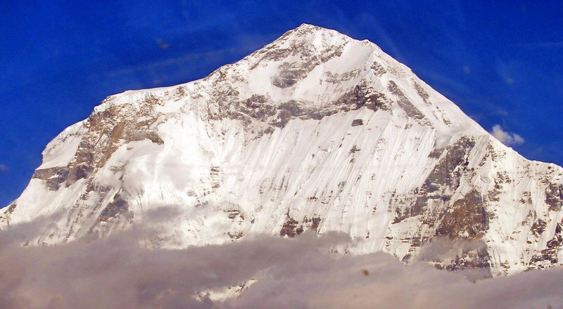
Thorung Peak, 2010
Sometimes opportunities just come along. More often than not they aren’t being asked to be in a ski mountaineering documentary in Nepal. I’ll rewind a bit…I’ve long been a fan of The Rest of Everest, a popular video podcast which originally chronicled Ben Clark’s ascent of Everest in 2003. I was in Telluride, CO and ended up introducing myself to Ben, who had just returned from an attempt to climb a new route on Baruntse as part of his new series, Ski the Himalayas. After hitting it off, we ended up climbing together near Telluride and stayed in touch. A year later, Ben invited me to join him, Telluride mountain guide Jon Miller, skier Erik Dalton and cameraman/skier Chris Dalton on an expedition to Saribung, a remote 6000m peak in the kingdom of Mustang, part of modern Nepal. It took some thinking over, as I never thought I’d be heading to the Himalaya for my first expedition, but I was soon on my way.

Dasain festival in Kathmandu’s Durbar Square

“Foothills” near Pokhara
Nepal was life changing as soon as I stepped off the plane. Praising the people of Nepal has become cliché, but everything you hear is true. I fell in love with the people and culture. While I was certainly confronted with the poverty, chaos and, at times, filth, in Kathmandu, I found the country fascinating, the people beautiful, remarkably kind and hard working, and the landscapes were beyond comparison. This is one of the world’s magical places.
Getting to the Mountains
This was my first trip to Asia, and simply getting close enough to see Saribung was supposed to take a few weeks. The flights from San Fransisco to Kathmandu via Hong Kong and Dhaka, Bangladesh took 36 hours. Nepal was chaotic as soon as we stepped off the plane. Onlookers snagged our bags and demanded compensation for “helping” us move them the short distance to our van. Maoists deposed Nepal’s king in 2008 and have been running the country in what seems to be a similarly corrupt way to their predecessors. My first day around Thamel, Kathmandu’s bustling, seedy tourist district was quite an experience. The streets are narrow, windy and have everything from foot traffic, livestock, buses, rikshas and of course motorized scooters, all of whom play a crazy game of frogger/chicken with each other. We spent the first few days getting supplies, securing our climbing permit from the Ministry of Tourism and Civil Aviation (go figure!) and eating fantastic food. On the holiest day of the year, the last day of the Hindu and Buddhist festival of Dasain, I walked down the medieval streets to Durbar Square. Here, there were thousands of Nepalis, all dressed in their finest. Fresh blood pooled from goat sacrifices and marigolds were everywhere. As it was raining, many of the tourist merchants were overly excited to see a westerner, and after buying a few things, one was so happy for the business that he gave me a silver bracelet as a gift.
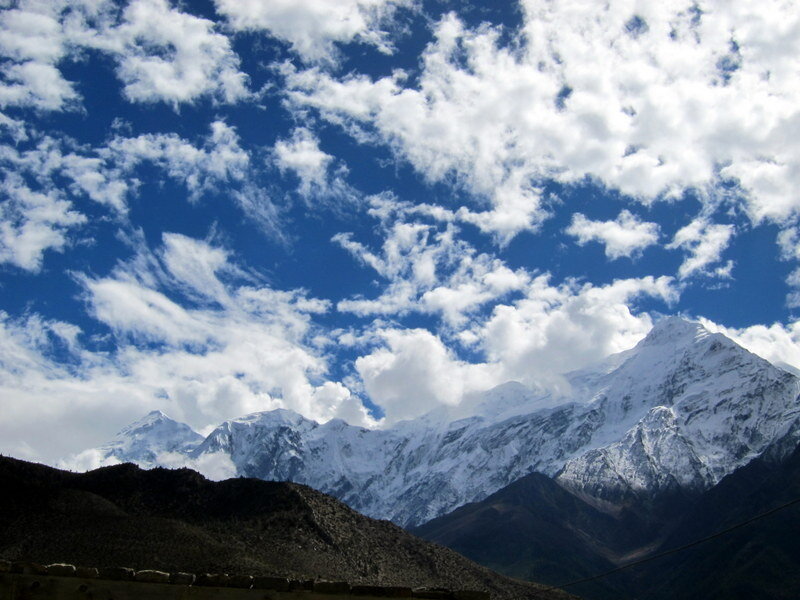
The 14,000 ft south face of Dhaulagiri, the world’s 7th highest mountain
Nilgiri towers above Jomsom
On the third day, we flew to Pokara, Nepal’s second largest city and the jumping off point for treks into the Annapurna region. Pokhara is a lovely city located on the shores of Phewa Tal. Slightly lower in elevation than Kathmandu, it’s absolutely in the jungle, but from the city, the world’s highest peaks such as Dhaulagiri, Annapurna and Macchapucchare, the holy mountain shaped like a fish tail, dominate the skyline. Another Twin Otter flight the next day brought us to Jomsom and instantly to the Himalaya.
It was in Jomsom that our expedition took quite the turn. We quickly learned, after several hours of heated discussion with a local horseman, that our organizers had secured us mules, and not porters for the upcoming 50-60 mile approach to base camp. This proved to be a fateful decision, as landslides had essentially made the route impassable for livestock. Furthermore, due to Dasain and the general difficulty of logistics in the developing world, it became evident that seeing, much less climbing Saribung would be next to impossible. After mulling over our options for the rest of the day, Ben decided to change our objective to the much closer 20,157 ft Thorung Peak, located just off the famous Annapurna Circuit trek.

Textiles in Marpha, the apple capital of Nepal
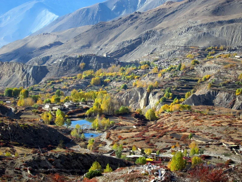
Fall colors in Muktinath

Puja ceremony in Muktinath
We spent another day in Jomsom while permit issues, and other logistics were secured, and hiked a few miles down the Kali Gandaki river valley to Marpha. The Kali Gandaki, known as the windy valley, is the deepest river valley in the world, cutting a 21,000 foot deep gorge between Dhaulagiri and Annapurna, the world’s 7th and 10th highest peaks. The scenery walking to Marpha was spectacular and incomparable in scale. High above us towered Nilgiri, and the white and red of the Buddhist architecture, the green of the apple orchards and the rich blue of the sky were incredible. The next day, we loaded jeeps for the drive to Muktinath, the end of the line for us. This was certainly the craziest ride of my life, as the teenage drivers seemed to take letting up on the accelerator as a sign of weakness. At multiple points, we accelerated into blind corners with thousand foot dropoffs only to slam on the brakes and narrowly avoid killing a trekker, porter or goat.

Dramatic scenery on the approach to base camp
To Base Camp
Muktinath, located close to 13,000 feet is a holy place with a monastery over 500 years old. This is a pilgrimage site for many Indians. We spent a few days camped behind a tea house acclimatizing and exploring around. On the second day, we went to a nunnery for a puja, a Tibetan Buddhist ceremony in which we ask the mountain gods permission to safely visit their slopes. In our case, nuns chanted for several hours while we listened, reflected and drank a continuous supply of chai and yak butter tea. Needless to say, as soon as we left, the guys ran to the bathroom! We outlined a plan to bring us to base camp. We would ascend to Phedi, a mud constructed tea house at 14,000 feet, then take some acclimatization hikes before ascending to our 17,800 ft base camp on Thorung La, the highest pass on the Annapurna Circuit. A few small storms hit while we acclimatized, and the fresh coats of powder made the hills light up in a beautiful white.
The Climb
At base camp, I definitely felt the altitude. I was now sleeping several thousand feet higher than I’d ever been, and the effects were noticeable. Yak cheese pizza was simply unappetizing. After a rest day, we headed up to check out the lower part of the route. We climbed a few hundred meters and the guys got some sweet powder skiing in.

Thorung Peak from base camp

Ben carving turns in powder at 19,000 feet
As we planned our summit bid, a large windstorm came through. We’d set our wake up time for 3 AM and I fully expected it to be called off. The wind was of a tent-shredding character, no longer a nuisance but something of an adversarial nature. While we forced down some breakfast in the awful kerosene fumes of our kitchen tent, the look on everyone’s faces was simply reluctant and tired. I certainly wasn’t giddy and excited as on most of my previous climbs. Altitude has a way of creating a paralyzing apathy, the great equalizer. But we suited up nonetheless, and soon we were off into the frigid night.
The first hours to the base of the glacier were some of the coldest I’ve experienced. As we roped up in the pre-dawn light, I asked and confirmed that everyone’s hands and toes were completely numb. The sun couldn’t come up fast enough. The initial thousand foot snow slope seemed tiring and endless. Jon led the way and set a steady tempo up the face as we all battled blasts of spindrift. After a few hours, we crossed a few crevasses as we crested the sunlit shoulder. From there, the route went up the crux of the route, a short but steep and icy slope to the lower angled summit ridge.

Chulu West in the moonlight on summit day

Jon working steadily on the shoulder
By the time we reached the ridge, we had a beautiful Himalayan summit day, with views to the Annapurna range, the Chulu group and Tibet. It was spectacular. The summit was beautiful, and we took our time on top enjoying the views, eating and joking around. I even busted out the yoyo for a while. But soon it was time to head down. We split into two rope teams so that the guys could ski and film separately. It seemed like everyone loved the skiing, but high winds and variable snow conditions made the skiing in roped parties a bit difficult and we needed to stop often to address tangles. I was eager to keep moving down but I had fun filming a bit and running down the moderate snow.

The ridge to nowhere

Probably some of the highest yoyoing ever done

Erik skiing in what is unquestionably the Himalaya. Behind is Annapurna II, the world’s 16th highest mountain.
Scraping off the Mountain and Getting Home
The mountains have a way of always being in charge. After crossing descending off the shoulder, we were now on the final snow slopes before the hike across some slabs and moraines back to base camp. It was here that Ben and I unroped as we’d crossed the last of the crevasses. Just below us, Erik, Jon and Chris stayed roped up and rested.
Thwump! Even if you’ve never heard or seen an avalanche, the gut feeling with one is instantly bad. I always thought avalanches would be fast, but the next few seconds unraveled in slow motion. A wind slab broke off about 10m below me…just above the team of three. “AVALANCHE!” I yelled. It was certainly disorienting for me to look at and I could tell the guys were confused, thinking they were standing still while slowly picking up speed. Things looked pretty mellow at first, but about ten seconds later, I knew we had an ordeal on our hands. First Chris, then Jon, tumbled down the slope yard-saling gear as they went. First a ski popped up, then a mitten. Crap, this is bad. I knew they didn’t have too long of a runout before the powder-covered slabs below. Erik was their only hope. He brilliantly skied out to the right, then dug his edges in and fell with all his weight onto his Whippet, a ski pole with a small ice pick built into the handle. Somewhat miraculously, he held the fall of the two others.
Ben and I sprung into motion. I quickly ran to Erik who was fine but still holding the weight of the other two. I tried to hammer in a picket, but the soft snow wouldn’t hold it. By this point, Jon, who had fallen over 100m to nearly the base of the route, had untied and was collecting himself at the bottom. It became obvious that Chris had gotten the worst of the avalanche as he was missing a ski. I ran down to him, hammered in a picket and got him off the rope. Ben and I then had Erik untie and ski to the bottom while we rigged up a system to lower Chris off the route. It was then evident that that everyone had gotten away uninjured and made it safely to our concerned cookstaff who had scrambled up to the base of the route.

I snapped this self portrait as soon as I reached the safety of my tent. I was too emotionally numb to muster anything other than this altitude-addled expression.

Harvest in Ghasa, Kali Gandaki valley
The next morning, I ran down to Muktinath in a Sherpa-esque manner, my acclimatization paying off. The freakish sudden death of a German tourist in our tea house cast a funky mood over the following day, Halloween, coincidentally enough. Jon, who had provided CPR was particularly shaken up. On a more practical note, it meant that getting to Kathmandu would be more difficult as we couldn’t find a jeep, and we couldn’t get on our flight from Jomsom to Pokhara. Not wanting to wait for an iffy flight the next day, we decided to keep the momentum going, and opted for the busride down the Kali Gandakhi river valley, the deepest in the world.
It was a spectacular ride, but one of the bumpiest and wildest drives I’ve been on. We faced traffic jams of hundreds of goats, several thousand foot dropoffs, and rapids that reached over the wheels, all while bouncing in a multicolored bus with a disco ball blaring Nepali pop music. After 14 or so hours, we pulled into Pokhara and promptly went to sleep. The next day, we explored Pokhara before catching our flight back to Kathmandu. There, we had some more logistical matters to take care of, but I was able to see some more of the city and eat some more good food.
One morning, I tried one of the more touristy things I’ve ever done, but loved it. It was a sightseeing flight where all the great peaks of the Himalaya were laid out. It was a strange feeling looking UP nearly 10,000 feet out the cockpit window at Everest from our cruising altitude of 20,000 feet.
I don’t really have a great way to end this, as the trip finished with 36 hours of relatively painful international flights back to San Francisco. Nepal will always be with me though, both as an ancient kingdom with a wonderful culture and as the throne to the mountain gods.

Erik and Jon having fun with Phude, Surnam, and Dawa. We had an absolutely wonderful time with our Sherpa cookstaff.

Everest, Nuptse, Lhotse, Ama Dablam. Only in a few places do you look up at mountains from cruising altitude.
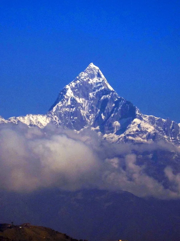
Macchapucchare, the holy mountain.